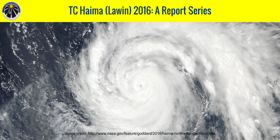
REPORT NO. 5 TC Haima Impacts 21 October 2016, 09:00 PM PHT
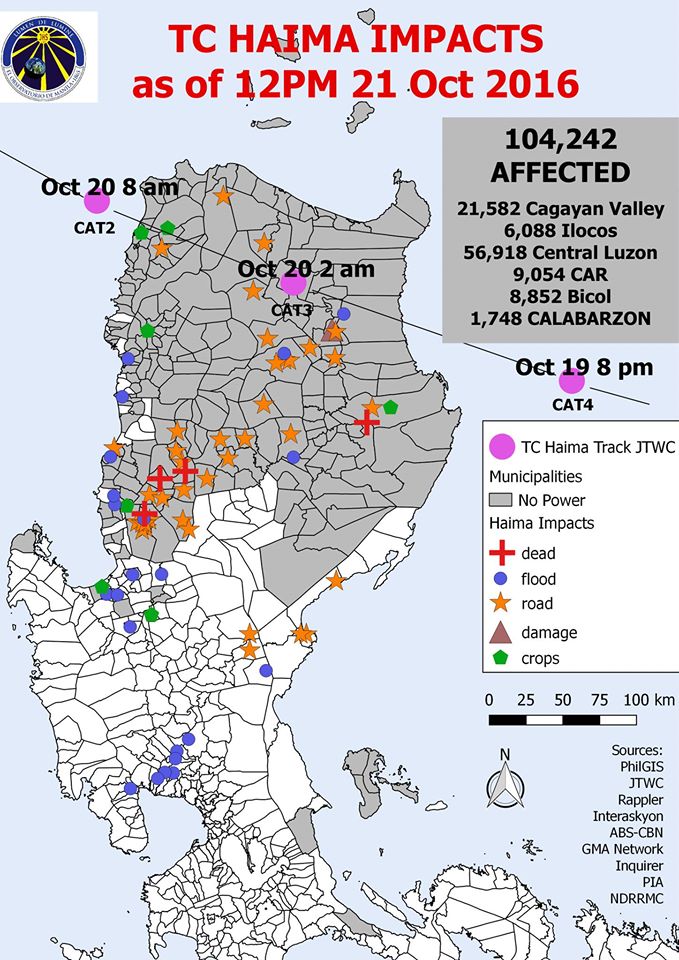
Image source: MO Facebook page, 22 October 2016, 1:12 AM PHT
As of 12PM Oct 21, 2016, there has still been no power in areas in the direct path of TC Haima (Lawin). Damages, floods, destroyed crops, and road debris have been reported in Isabela, Cagayan, Apayao and Ilocos Norte. Roadblocks, and landslides were reported in CAR, which caused six deaths. Flooding also occured in low lying areas in La Union, Pangasinan, Pampanga, and Aurora. 104,242 persons were affected by TC Haima (Lawin) according to NDRRMC.
(Sources: Rappler, Interaksyon, ABS-CBN, GMA Network, Inquirer, PIA, NDRRMC)
REPORT NO. 4. TC Haima Path 20 October 2016, 3:00 PM PHT
File: tchaima_report4_20oct2016-3-00pm
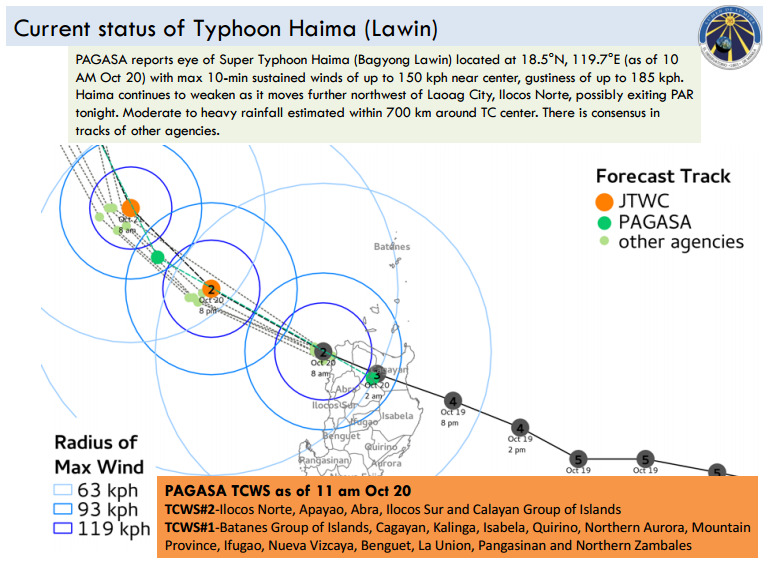
 PAGASA reports eye of Super Typhoon Haima (Bagyong Lawin) located at 18.5°N, 119.7°E (as of 10 AM Oct 20) with max 10-min sustained winds of up to 150 kph near center, gustiness of up to 185 kph. Haima continues to weaken as it moves further northwest of Laoag City, Ilocos Norte, possibly exiting PAR tonight. Moderate to heavy rainfall estimated within 700 km around TC center.
- Signal #2 Ilocos Norte, Apayao, Abra, Ilocos Sur and Calayan Group of Islands; Signal #1 Batanes Group of Islands, Cagayan, Kalinga, Isabela, Quirino, Northern Aurora, Mountain Province, Ifugao, Nueva Vizcaya, Benguet, La Union, Pangasinan and Northern Zambales
- Multi-tracks show agreement in the track as it moves west-northwest.
- According to JTWC (as of 5pm Oct 20), Haima still Cat 2 (max 1-min wind speed: 167 kph) with eye located near 19.0°N, 118.8°E (over sea); forecast to weaken as it moves west-northwest
- Satellite rainfall from 2.30PM-3:29PM 20 Oct shows intense rainfall of 20-30 mm/hr over northeast Luzon and surrounding eye (SW section) of tropical cyclone.
- Northern Luzon has received more than 250 mm rainfall in the past 24 hours.
- Past destructive typhoons with similar tracks include TY Megi (Juan) (2010), TY Zeb (Iliang) (1998) and TY Sarika (Karen) (2016)
REPORT NO. 3. TC Haima Path 20 October 2016, 9:00 AM PHT
File: tchaima_report3_20oct2016-9-00am
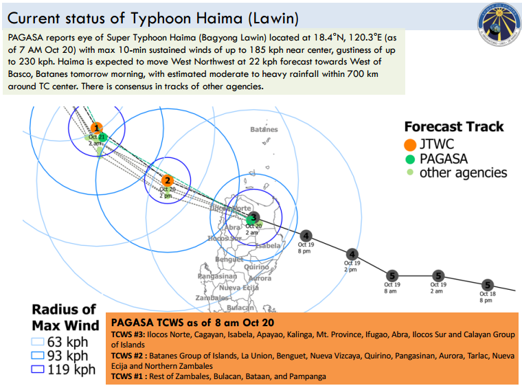
- PAGASA reports eye of Super Typhoon Haima (Bagyong Lawin) located at 18.4°N, 120.3°E (as of 7 AM Oct 20) with max 10-min sustained winds of up to 185 kph near center, gustiness of up to 230 kph. Haima is expected to move West Northwest at 22 kph forecast towards West of Basco, Batanes tomorrow morning, with estimated moderate to heavy rainfall within 700 km around TC center.
- Haima has made landfall over Penablanca, Cagayan around 2am Oct 20.
- Signal #3 over Ilocos Norte, Cagayan, Isabela, Apayao, Kalinga, Mt. Province, Ifugao, Abra, Ilocos Sur and Calayan Group of Islands; Signal #2 Batanes Group of Islands, La Union, Benguet, Nueva Vizcaya, Quirino, Pangasinan, Aurora, Tarlac, Nueva Ecija and Northern Zambales
- Multi-tracks show agreement in the track as it continues to move west-northwest.
- According to JTWC, Haima weakened to Cat 2 (max 1-min wind speed: 176 kph) with eye located near 18.4°N, 120.3°E (as of 8am Oct 20). Haima is forecast to leave PAR (with max winds of about 167 kph) over West Northwest of Luzon before 8pm Oct 20.
- As Typhoon Haima crossed Cagayan and Apayao, intense winds, rainfall associated with TC over surrounding areas. Other potential critical areas include vulnerable regions in CAR where TC rainfall may be enhanced by interaction with mountains.
- Satellite rainfall from 8.30AM-9:29AM 20 Oct shows intense rainfall of 25-30 mm/hr over Ilocos Norte, Ilocos Sur, La Union, Apayao, Abra and around eye of tropical cyclone
- Model forecast shows potentially heavy 1-day total rainfall (more than 240 mm) over Abra, Ilocos Sur
- Past destructive typhoons with similar tracks include TY Megi (Juan) (2010), TY Zeb (Iliang) (1998) and TY Sarika (Karen) (2016)
REPORT NO. 2. TC Haima Path 19 October 2016, 9:00 PM PHT
File: tckaren_report2_15oct2016-9-00am
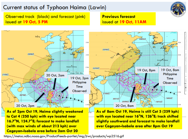
- PAGASA reports eye of Super Typhoon Haima (Bagyong Lawin) located at 17.1°N, 123.5°E (as of 7 PM Oct 19) with max 10-min sustained winds of up to 225 kph near center, gustiness of up to 315 kph. Haima is expected to make landfall over Cagayan-Isabela area later tonight or early morning tomorrow (Oct 20) before moving to Apayao and Ilocos Norte, with estimated moderate to heavy rainfall within 800 km around TC center.
• Signal #5 is raised over Cagayan, Isabela, Kalinga, Apayao, Northern Abra and Ilocos Norte; Signal #4 Rest of Abra, Ilocos Sur, Mt. Province, Ifugao and Calayan Group of Islands
• Multi-tracks show agreement in the track as it moves west-northwest.
• According to JTWC (as of 2pm Oct 19), Haima slightly weakened to Cat 4 (max 1-min wind speed: 250 kph) with eye located near 16.7°N, 124.7°E. Haima is forecast to make landfall (with max winds of about 213 kph) over Cagayan-Isabela area before 2am Oct 20.
• Cagayan, Isabela to experience intense winds, rainfall associated with TC upon landfall. Areas previously affected by Typhoon Sarika (Karen) may also experience rainfall. Other potential critical areas include vulnerable regions in CAR where TC rainfall may be enhanced by interaction with mountains.
• Satellite rainfall from 8.30PM-9:29PM 19 Oct shows intense rainfall of 25-30 mm/hr over eastern coast of Cagayan, Isabela and around eye of tropical cyclone
• Model forecast shows potentially extreme 1-day total rainfall (may exceed 350 mm) over Isabela, Cagayan, CAR region (Kalinga, Mt. Province, Benguet, Abra), Ilocos Region (Ilocos Sur, La Union)
• Past destructive typhoons with similar tracks include TY Megi (Juan) (2010), TY Zeb (Iliang) (1998) and TY Sarika (Karen) (2016)
REPORT NO. 1. TC Haima Path 19 October 2016, 3:00PM PHT
File: tchaima_report1_19oct2016-3-00pm
Summary:
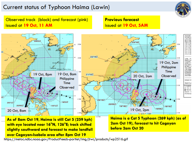
- PAGASA reports eye of Super Typhoon Haima (Bagyong Lawin) located at 16.5°N, 124.9°E (as of 1 PM Oct 19) with max 10-min sustained winds of up to 225 kph near center. Haima expected to make landfall over Cagayan-Isabela area later tonight or early morning tomorrow (Oct 20) before moving to Apayao and Ilocos Norte, with estimated moderate to heavy rainfall within 800 km around TC center.
- Signal #5 is raised over Cagayan and Isabela, Signal #4 over Apayao, Kalinga, Ilocos Norte, Abra, Ilocos Sur, Mt. Province, Ifugao and Calayan Group of Islands
- Multi-tracks show agreement in the track as it moves west-northwest.
- According to JTWC (as of 8am Oct 19), Haima is Cat 5 (max 1-min wind speed: 259 kph) with eye located near 16°N, 126°E. Haima is forecast to make landfall over Cagayan-Isabela area after 8pm Oct 19.
- Cagayan, Isabela to experience intense winds, rainfall associated with TC upon landfall. Areas previously affected by Typhoon Sarika (Karen) including Aurora, Quirino, Nueva Vizcaya may also experience rainfall. Other potential critical areas include vulnerable regions in CAR where TC rainfall may be enhanced by interaction with mountains.
- Satellite rainfall from 2.00PM-2:59PM 19 Oct shows intense rainfall of 25-30 mm/hr near eye (SW section) of tropical cyclone
- Based on model forecast, potentially extreme 1-day total rainfall (may exceed 350 mm) over Isabela, Cagayan, CAR region